Methodology – Scouting
Our goal is to scan the stations we have found using the resources described in the previous blog entry.
Discovering the best method of capturing the data that will be used to create 3D models of these stations has been a learning process, and while there are similarities between buildings, each one can present their own challenges. The landscape around the building location has it’s own challenges.
Examining the building location
Typically we use a drone controlled by Jean-Rene Leblanc or Hesam Rezaei to capture the roof details and surrounding landscape, and land-based photogrammetry to capture the facade of the building. Environmental variables which can impact the results include:
- excessive sunlight, which casts dark shadows or overexposes some images,
- trees or overgrowth which can limit the use of the drone or affect the path used to capture land-based images
- man-made things such as tents, vehicles and stuff leaning against the buildings.
Understanding the space constraints of the location to be scanned helps determine the necessary method for capturing enough information.
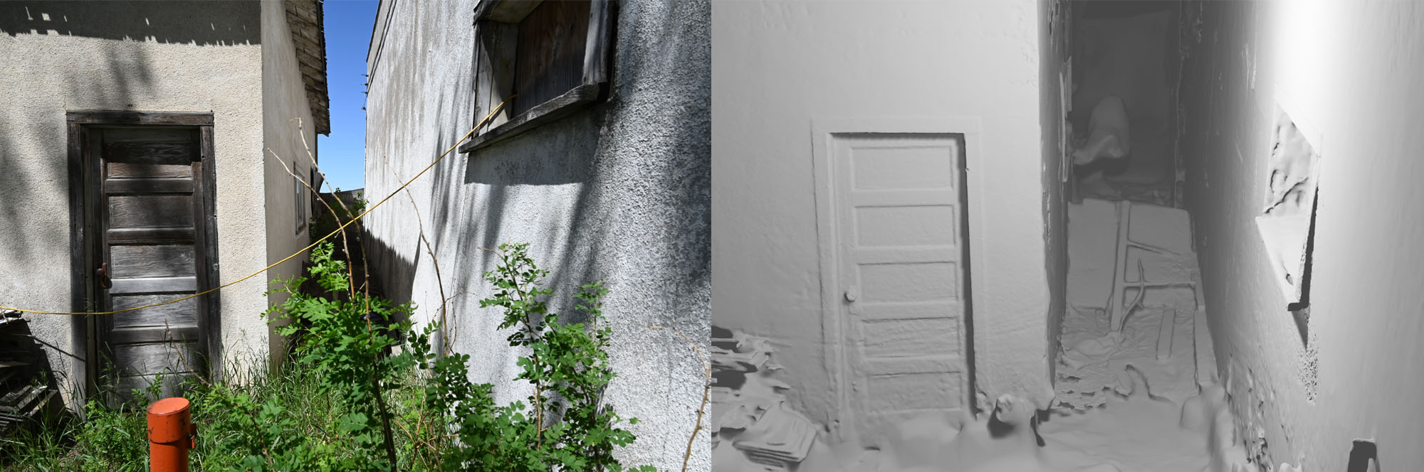
At the old truck stop in Staveley a narrow channel between two buildings was difficult to capture from the ground, so an orchestrated method using the drone and ground images was used. This let us capture the space under the eaves where the drone couldn’t see, and the walls and surfaces and some of the random items on the ground which I could not see with the camera. It is easier to do this with two people rather than try to remember what you captured in previous formats.
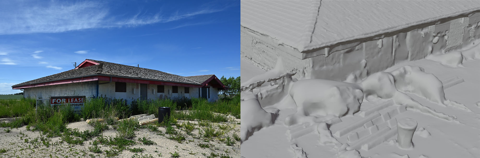
In another case a large number of high weeds surrounding the building, combined with deep shadows from a bright sunny day led to a lack of detail captured on the highly textured wall. This model is a good example of why the scans are not always immediately usable. You can see the wall texture on the left in the render, and that detail is missing where the shadows were darkest, and where the weeds obscured the view. This area was captured from multiple angles, close and farther away in many images, but the detail was still lost due to the extremely close angles.
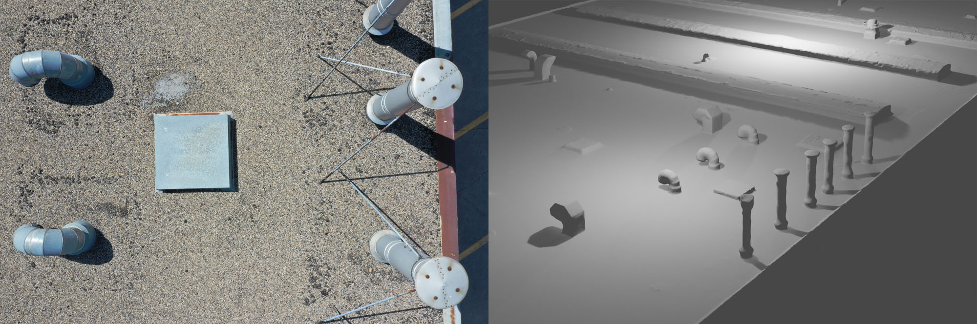
Another reason for scouting the locations by ground and air is to understand what is necessary to scan, and what will interfere with the use of the drone. Overhanging trees, support wires and power lines will all affect the path we take to capture details. We also use the drone to understand the topography of the roof. Even with a complete set of images, however, the taller things are and closer to the drone, the less detail will be captured. There is a fine line between capturing a large area clearly and smaller elements in detail. A one-size-fits-all method will not work with several of the different shapes. For example, capturing from a height will not give us details of the underside of some vents on the roof.
A preliminary scout of the surface you will be capturing will help you determine the best path for the drone and ground based photography to capture the details necessary to build a complete model. It is sometimes difficult to assess the images on location, and returning is not always an easy affair, considering how many permissions may be required to access the space.
Even a visit which does not result in a perfect scan of the building will be useful for creating the final model. The quality of that scan will determine if the scanned model can be shared online. A blobby or imperfect scan of a building can still be used create a model by hand using shapes and textures. This is described in a separate blog entry.
The process starts with walking around the building to figure out how best to capture the various details. Here is where we can figure out the best method for working around obstacles, or understand the details we want to capture, such as wires, pipes, electric boxes, lighting fixtures, windows, etc. Even the angles of the cameras can impact how things are ‘built’ through the 3D software. Over time while working with the images we have discovered some of the things to avoid, but first I would like to concentrate on some best practices.